
Modelled Targets and Triggers
Riverfly sites in England and Wales now have two automatically generated values: the Modelled Trigger Level and the Modelled Target Score. This page explains how these are produced, and how they can be interpreted.
Where to find Modelled Targets and Triggers
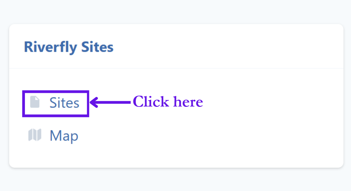
Anyone can see the Modelled Target Score and Modelled Trigger Level for any site already registered. On your home page, click on ‘Sites’ under ‘Riverfly Sites’ (if you don’t have a database account, you can sign up for one here). You can then search for the site you are interested in, and click on the listing.
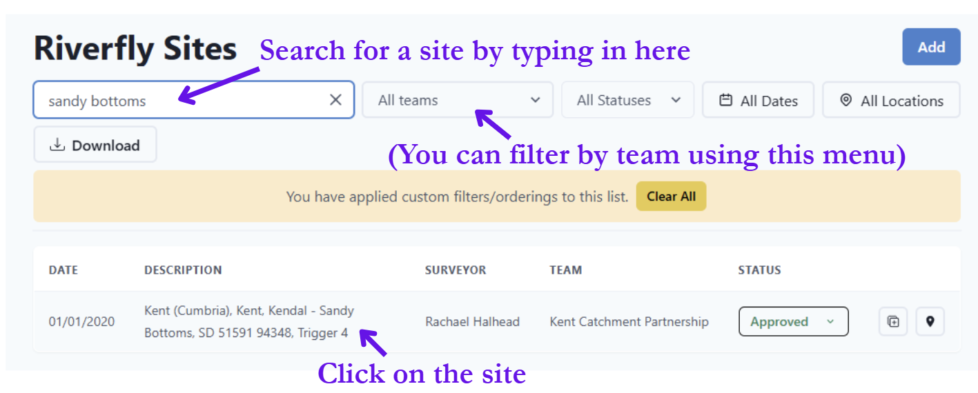
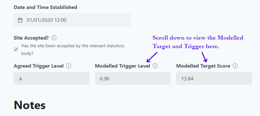
If you are a co-ordinator, you will see the Modelled Trigger Level and Modelled Target Score appear here automatically when you assign a location to a new site.
The Modelled Target Score for a site is also shown when you fill in your survey results for that site, below the survey’s RMI score.
What these values mean
Modelled Trigger Level
Modelled Trigger Levels are intended to be used at RMI sites for which a trigger level has not been agreed with an ecology contact. Typically, these will be newly registered sites. The Modelled Trigger Level is intended to be a guide.
The Modelled Trigger Level is approximately half of the Modelled Target Score, and is automatically generated when a site’s location is assigned. This is not the same as the Agreed Trigger Level (set by the Environment Agency in England), which the co-ordinator manually enters when it has been provided by the ecology contact.
Modelled Target Score
This is an indication of what the RMI score might be expected to be if the stream or river was minimally impacted by human influences. Modelled Target Scores vary considerably between sites. This is because different watercourses have different physicochemical properties that influence the composition of the invertebrate communities. For example, a Modelled Target for a swiftly-flowing upland stream will typically be higher than that of a slow-flowing lowland river.
The Modelled Target Score is a site-specific score that gives an indication of the ecological potential of the river. It gives an idea of what the RMI score should be, if it was free from human influences.
It is possible to exceed the Modelled Target Score at sites that are better than average for the type of river.
How these values are generated
The Modelled Targets and Triggers are generated using the River Invertebrate Prediction and Classification System (RIVPACS). Specifically, RIVPACS Model 44 was used. This model predicts the expected composition of the freshwater invertebrate community at a site in the absence of significant anthropogenic stress. In other words, the RIVPACS model can tell you which riverflies, and in what quantities, you would expect to see at a particular site if it was free from the influences of humans, such as pollution. It bases this prediction on a series of geographic parameters, and the alkalinity of the stream. This predicted assemblage of invertebrates for a site can then be converted into an RMI score, and this is what we have called the Modelled Target Score.
Modelled Trigger Levels are 50.3% of the Modelled Target Score for a site. For example, a site with a Modelled Target of 13.10 will have a Modelled Trigger of 6.59. This figure of 50.3% was decided upon based on how the Water Framework Directive (WFD) Poor-Moderate Boundary Score is calculated – see table below.
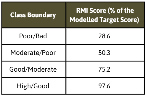
This table doesn’t show the actual WFD classification bands, but they are calculated using the same method as were used on RIVPACS Model 1 for the WFD, and then mapped over to Model 44.
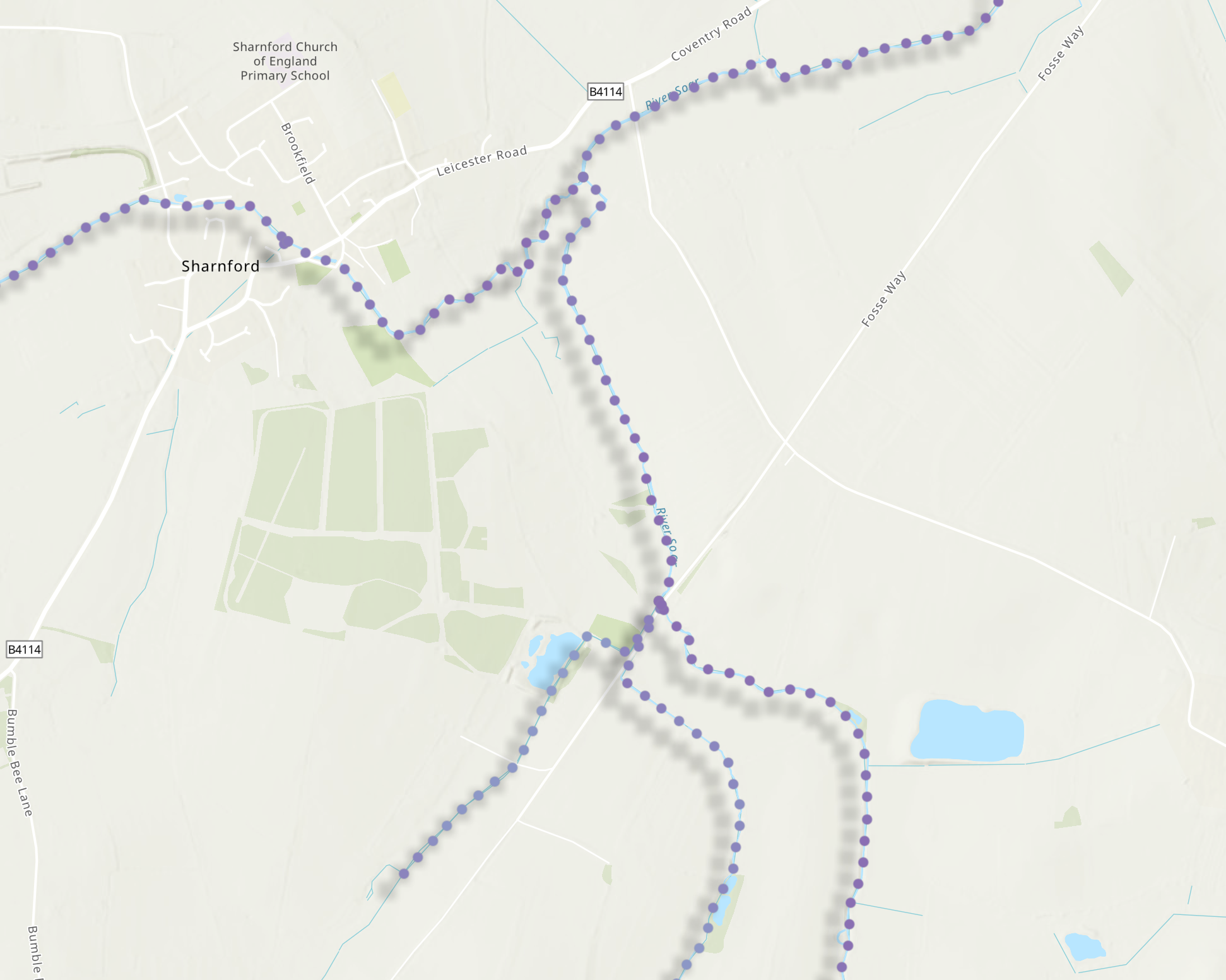
The model was run at a 50 metre resolution across the English and Welsh river networks, meaning there are ‘dots’ along every river, each one allocated with a Modelled Target and Trigger value. In the Riverfly database, when a site is registered, it pulls the Modelled Target Score and Modelled Trigger Level from the dot nearest to the site’s location on this hidden layer. For this reason, it is very important to check that the grid reference of your sample site is accurate and its location appears in the correct place on the map displayed in Cartographer. You can view the map of modelled values on CaSTCo’s website here.
Modelled Trigger vs Agreed Trigger
The Modelled Trigger Levels are advisory. For this reason, Ecology Contacts (ECs) at statutory bodies are under no obligation to follow up on surveys that get a score below the Modelled Trigger Level. It is only when a survey breaches the Agreed Trigger Level that the ecology contact should be notified.
Whilst these modelled scores can be used as guidance by the EC when setting the Agreed Trigger Level (e.g. the team behind this work has recommended setting the Agreed Trigger Level as: Site Average – (0.3 × Modelled Target)), the EC has the final say on establishing the Agreed Trigger, which may be based on RMI data collected over the previous 3-12 months, local monitoring priorities, and local knowledge.The Modelled Trigger Level of your site might be higher than the Agreed Trigger Level. A typical reason for this may be that if the site is known by the Statutory Agency to be affected by long-term, chronic pressures, then the EC may set a low trigger level to avoid repeated unhelpful breaches. This may be based on a review of RMI data over several months to a year.
It is also possible that the Agreed Trigger Level is too low. This may reflect improvement at the site, perhaps through river restorations, or it may be that the EC has set a low trigger level as an interim measure while long-term RMI data accumulates. In these cases, the Modelled Trigger Score might be more useful, and this can be discussed with the EC.
Important notes
RIVPACS assumes all available habitats at the site have been sampled in proportion to their cover. Therefore, if a fully representative sample is not possible (e.g. parts of the river are too deep to access safely), the Modelled Target and Trigger are not applicable.
These values are currently only available for England and Wales because of the availability of the data required to generate the predicted scores. We hope to expand this to Scotland and Northern Ireland if the relevant data can be obtained.
If no Modelled scores appear when you are setting up a site, check that you have provided an accurate grid reference for the site. The scores are drawn from the nearest dot on our hidden map layer (which are on a 50m grid beside every river), but if the site co-ordinates are too far away from any of these points, no Modelled Trigger or Target will be generated.
The work behind this project was undertaken using funds from CaSTCo.
